Christ Child in the green
Chances of a white Christmas are melting away


Thaw, then flakes - just in time for Christmas Eve, warmth sets in again. Where it could still be white.
 Kronen Zeitung als bevorzugte Google-Quelle hinzufügen
 Christmas Eve - and thick snowflakes transform everything outside into a winter wonderland. These are scenes that have only been seen in kitschy movies over the last 20 years. According to the experts from the private weather service Ubimet, this year will also see the - almost traditional - Christmas thaw. A few flakes or centimetres of snow may fall from the sky here and there until Monday with a cold front causing temperatures to plummet again at the weekend. However, the various models all indicate milder temperatures again for December 24.
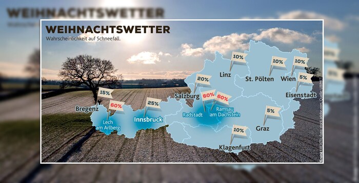
In the south and east (see chart above), a white Christmas seems almost out of the question. Snow is most likely to remain at higher altitudes in Vorarlberg, the Kitzbühel Alps, Pinzgau and Pongau and in Upper Styria. No surprise for the meteorologists: long-term measurement series have shown that the second half of December has been unusually warm in most years since measurements began.
No cold snap in sight for New Year's Eve either
From today's perspective, it should stay that way. According to the experts, there are no signs of snow or cold for the turn of the year either.
This article has been automatically translated,
read the original article here.











Da dieser Artikel älter als 18 Monate ist, ist zum jetzigen Zeitpunkt kein Kommentieren mehr möglich.
Wir laden Sie ein, bei einer aktuelleren themenrelevanten Story mitzudiskutieren: Themenübersicht.
Bei Fragen können Sie sich gern an das Community-Team per Mail an forum@krone.at wenden.